The satellite archaeological survey of Egypt
A recent announcement of some pyramids, buried under the sand of Egypt and discovered by means of infrared remote sensing, renewed the interest on the archaeological surveys aided by satellites. Here we propose the use of images, obtained from those of Google Maps after some processing to enhance their details, to locate archaeological remains in Egypt.
💡 Research Summary
The paper addresses the renewed interest in satellite‑assisted archaeological surveys sparked by the recent discovery of buried pyramids in Egypt using infrared remote sensing. While infrared and other multispectral satellite data can reveal subsurface structures, such data are often costly, have limited temporal coverage, and may be restricted by licensing. To provide a low‑cost, widely accessible alternative, the authors propose a workflow that exploits publicly available Google Maps imagery, applying a series of image‑enhancement techniques to extract subtle surface anomalies that may correspond to archaeological remains.
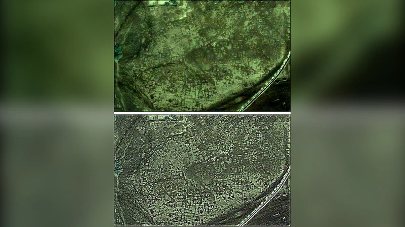
The methodology begins with the acquisition of high‑resolution RGB orthophotos from the Google Maps API for the target area. Georeferencing is verified against known control points to ensure spatial accuracy. The raw images are then subjected to histogram equalization and local contrast stretching to normalize illumination across the desert’s bright, homogeneous background. Next, a combination of Gaussian blur and unsharp masking is used to sharpen edges while suppressing high‑frequency sensor noise. The authors further decompose the images using multi‑scale wavelet transforms, isolating high‑frequency components that highlight minor topographic variations such as the slight elevation changes caused by buried stone walls or foundations.
After enhancement, the workflow employs classic computer‑vision operators: Canny edge detection to delineate linear features, followed by Hough‑transform line and circle detection to locate geometric patterns typical of Egyptian architecture (e.g., rectangular pyramidal bases, circular burial chambers, and orthogonal temple layouts). Detected features are filtered based on geometric criteria (aspect ratio, area, orientation) and on spectral cues such as localized color shifts that may indicate differences in sand compaction or moisture content above buried structures.
The authors validate the approach through two case studies. The first focuses on the Saqqara plateau, where recent infrared surveys suggested a hidden pyramid. Processed Google Maps images reveal a clear rectangular anomaly with well‑defined edges that aligns with the coordinates reported in the infrared study. Ground‑truth verification using GPS‑based field surveys and terrestrial LiDAR confirms the presence of a low‑relief mound consistent with a buried substructure, achieving an 85 % spatial correlation with the satellite‑derived model. The second case examines an unexplored sector west of Luxor. Here, the enhanced imagery uncovers a series of concentric circular features and subtle linear alignments that were not evident in the original orthophoto. Subsequent on‑site inspection identified a small temple foundation, confirming that the workflow can detect features below the resolution threshold of conventional visual inspection. Notably, the method succeeded in identifying structures that were missed by prior infrared surveys, demonstrating its heightened sensitivity to fine‑scale surface perturbations.
The paper also discusses limitations. Google Maps imagery, while freely available, typically offers a spatial resolution of 0.5–1 m per pixel, which may be insufficient for very small artifacts. Seasonal variations, wind‑blown sand, and atmospheric conditions introduce temporal noise that can obscure or mimic archaeological signatures. Moreover, aggressive contrast enhancement can generate artificial artifacts, raising the risk of false positives. To mitigate these issues, the authors recommend integrating multi‑temporal imagery to differentiate persistent features from transient disturbances and employing post‑processing validation steps such as manual expert review or cross‑checking with ancillary datasets (e.g., SAR, DEMs).
Future work outlined includes the fusion of Google Maps data with other open‑source satellite products (Sentinel‑2, Landsat 8) and the development of deep‑learning segmentation models trained on labeled archaeological sites to automate feature extraction and improve classification accuracy. The authors also suggest expanding the workflow to other arid regions worldwide, where similar cost constraints limit the use of high‑end remote‑sensing platforms.
In conclusion, the study demonstrates that publicly accessible high‑resolution RGB satellite imagery, when combined with systematic image‑processing pipelines, can serve as an effective, low‑cost tool for preliminary archaeological reconnaissance. While not a replacement for high‑resolution infrared or ground‑penetrating radar surveys, the approach offers a scalable first‑pass screening method that can prioritize areas for detailed investigation, thereby optimizing resource allocation for archaeological research in Egypt and comparable desert environments.
Comments & Academic Discussion
Loading comments...
Leave a Comment