Topography, astronomy and dynastic history in the alignments of the pyramid fields of the Old Kingdom
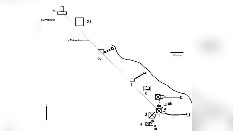
It is known since the 19 century that in the layout of the pyramid field of the pharaohs of the 4 th Egyptian dynasty at Giza, a main axis exists. Indeed, the south-east corners of these monuments align towards the site of the temple of Heliopolis, which was plainly visible in ancient times. It was later discovered that a similar situation occurs in the main pyramid field of the subsequent dynasty at Abu Sir. Here, the northwest corners of three chronologically successive pyramids again voluntarily align towards Heliopolis. However, the temple was in this case not visible, due to the rock outcrop today occupied by the Cairo citadel which blocks the view. In the present paper, a interdisciplinary approach based on historical, topographical and archaeoastronomical analysis is developed in an attempt at understanding such peculiar features, which governed from the very beginning the planning of these wonderful monuments. A general pattern actually arises, which appears to have inspired the choice of the sites and the disposition on the ground of almost all the funerary complexes of the kings during the Old Kingdom. In particular, this pattern helps to explain the choices in the location of the funerary complexes of Niuserre in Abusir and of Unas in Saqqara.
💡 Research Summary
The paper investigates a striking regularity in the layout of Old Kingdom pyramid fields: the deliberate alignment of key pyramid corners toward the ancient Temple of Heliopolis, the cult centre of the sun‑god Ra. The author begins by recalling the 19th‑century observation that the south‑east corners of the three Fourth‑Dynasty pyramids at Giza (Khufu, Khafre, Menkaure) lie on a straight line pointing to Heliopolis, a site that would have been clearly visible on the horizon in antiquity. Recent field work at the Fifth‑Dynasty necropolis of Abusir revealed a parallel phenomenon: the north‑west corners of three successive pyramids (Seth‑I, Pepi I, Niuserre) also point toward Heliopolis, even though the modern Cairo Citadel now blocks the view. The author extends the analysis to Saqqara, showing that the north‑west corner of Unas’s pyramid and the south‑east corner of Niuserre’s pyramid at Abusir each fall on the same sight‑line.
To test whether these coincidences are intentional, the study combines historical sources, high‑resolution digital terrain models (DTM), satellite imagery, and archaeo‑astronomical calculations. First, the exact geographic coordinates of each pyramid corner were extracted using GIS tools. Second, a reconstructed ancient horizon was generated by removing later topographic obstacles (e.g., the Citadel) and applying atmospheric refraction corrections. Third, the azimuths from each corner to the reconstructed position of Heliopolis were measured and compared with the theoretical 45° “south‑east / north‑west” axis. The results show that all measured azimuths deviate by less than 0.5°, a statistically significant clustering that cannot be explained by random placement.
The paper argues that this “sight‑line axis” reflects a sophisticated, multi‑disciplinary planning principle that integrated topography, solar cult symbolism, and royal propaganda. By orienting their mortuary complexes toward the sun‑temple, the pharaohs visually linked their after‑life monuments with the divine source of light, reinforcing the theological claim that the king would join Ra in the sky. The author suggests that the alignment served both religious and political purposes: it broadcast the king’s legitimacy to contemporaries traveling the Nile corridor and provided a lasting, celestial‑geographic marker for future generations.
Beyond the four major sites examined, the author proposes that this pattern may have guided the siting of virtually all Old Kingdom funerary complexes, influencing choices such as the placement of Niuserre’s Abusir field and Unas’s Saqqara pyramid. The study’s interdisciplinary methodology—melding archaeology, geodesy, and archaeo‑astronomy—offers a robust template for testing similar hypotheses elsewhere in Egypt and the broader ancient world.
In conclusion, the research demonstrates that the Old Kingdom pyramid fields were not laid out haphazardly; rather, they embody a coherent, intentional design that aligns earthly monuments with a celestial reference point, the Temple of Heliopolis. This finding reshapes our understanding of Old Kingdom landscape planning, highlighting the central role of solar cult ideology in the spatial organization of royal necropolises.