A New Combined European Permanent Network Station Coordinates Solution
The EUREF (International Association of Geodesy (IAG) Reference Frame Sub-Commission for Europe) network of continuously operating GPS stations (EPN) was primarily established for reference frame maintenance, and also plays an important role for geodynamical research in Europe. The main goal of this paper is to obtain an independent homogeneous time-series of the EPN station coordinates, which is also available in SINEX format. A new combined solution of the EPN station coordinates was computed. The combination was performed independently for every week, in three steps: 1. the stated constraints on the coordinates were removed from the individual solutions of the Analysis Centers; 2. the de-constrained solutions were aligned to ITRF2000; 3. the resulting solutions were combined using the Helmert block-ing technique. All the data from GPS week 900 to week 1302 (April 1997 - December 2004) were used. We investigated in detail the behavior of the transformation parameters aligning the new combined solution to ITRF2000. In general, the time-series of the transformation parameters show a good stability in time although small systematic effects can be seen, most likely caused by station instabilities. A comparison of the new combined solution to the official EUREF weekly combined solution is also presented.
💡 Research Summary
The paper presents a new weekly combined solution for the European Permanent GPS Network (EPN) station coordinates covering GPS weeks 900–1302 (April 1997 to December 2004). The authors aim to produce a homogeneous, high‑quality time series in SINEX format that overcomes the limitations of the official EUREF weekly combined solution, which relies on a fiducial (tight‑constraint) approach and exhibits jumps and seasonal artefacts due to changes in the underlying ITRF realizations.
The methodology consists of three distinct steps applied independently for each week. First, the authors remove the a‑priori constraints that most Analysis Centers (ACs) impose on a set of reference stations. Using the formalism of Brockmann (1996), the constrained solution (provided in the SINEX SOLUTION/ESTIMATE block) is expressed as a combination of an a‑priori solution and a free solution. By inverting this relationship (Equations 3 and 4), the free coordinates and their covariance matrix are recovered. For stations that are not explicitly constrained, a very large variance (≈10⁴ m²) is assigned, effectively imposing a loose constraint that prevents numerical instability while preserving the freedom of the solution.
Second, each de‑constrained weekly solution is aligned to the International Terrestrial Reference Frame 2000 (ITRF2000). A seven‑parameter Helmert transformation (three translations, three rotations, one scale) is estimated using all stations common to the AC solution and ITRF2000, except for 18 stations known to be unstable or poorly determined in ITRF2000. Weights are derived from the propagated coordinate uncertainties of both the AC solution and the ITRF2000 catalogue. Stations whose transformed coordinates differ by more than 3 cm from the propagated ITRF2000 positions are iteratively excluded, and the transformation is recomputed. This step guarantees that every AC solution is expressed in a common, globally consistent reference frame before combination.
Third, the authors combine the aligned weekly solutions using the Helmert blocking technique. The normal equations (inverse covariance matrices) of all AC solutions are summed, yielding a global normal equation whose solution provides the combined station coordinates. Prior to summation, each AC solution is scaled so that its mean formal coordinate error matches the mean error of all ACs for that week, ensuring homogeneity. No additional weighting beyond equal weighting of the ACs is applied; the authors tested alternative weighting schemes based on formal errors and residual analysis but found no significant improvement. Outliers are identified by comparing each AC’s coordinates to the combined solution; any station whose coordinate difference exceeds three standard deviations in any component is excluded from that AC’s solution (typically up to six stations per week).
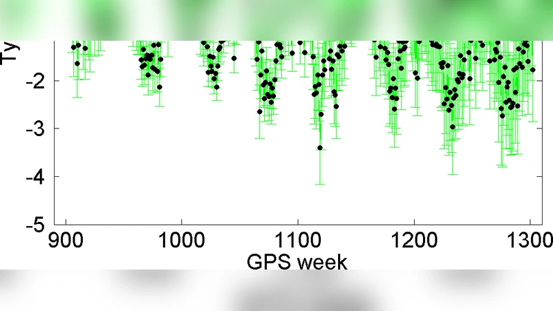
The resulting new combined solution is compared with the official EUREF weekly combined solution by computing transformation parameters to ITRF2000 for both products. The official EUREF solution shows pronounced seasonal variations and a clear jump of about 2.5 ppb in the scale parameter at GPS week 1143, coinciding with the transition from ITRF97 to ITRF2000. In contrast, the new solution exhibits markedly smaller jumps and reduced seasonal behaviour; its transformation parameters remain close to zero throughout the entire interval, indicating superior stability with respect to the reference frame. Residual systematic biases and minor seasonal signals are still present, likely caused by the inclusion of a few unstable stations in the alignment step. Correlation analysis reveals strong inter‑parameter correlations (e.g., Ty–Rx, Tz–Ry), reflecting the limited geographic extent of the EPN network and limiting the physical interpretation of individual Helmert parameters.
The authors conclude that removing tight fiducial constraints, aligning each AC solution to ITRF2000, and then applying Helmert blocking yields a more reliable, homogeneous coordinate time series than the traditional EUREF product. The new solution is made publicly available in SINEX format via the Institute of Applied Astronomy website and has been submitted to the EUREF Time Series Monitoring Special Project. The paper notes that future improvements could include re‑aligning to newer ITRF realizations (e.g., ITRF2004), incorporating variance‑component estimation for optimal weighting, and accounting for correlations among AC solutions that arise from shared observation data. Overall, the work provides a valuable resource for high‑precision geodetic and geokinematic studies across Europe.
Comments & Academic Discussion
Loading comments...
Leave a Comment