Measuring Urban Sprawl Based on Massive Street Nodes and the Novel Concept of Natural Cities
In this paper, we develop a novel approach to measuring urban sprawl based on street nodes and naturally defined urban boundaries, both extracted from massive volunteered geographic information OpenStreetMap databases through some data-intensive computing processes. The street nodes are defined as street intersections and ends, while the naturally defined urban boundaries constitute what we call natural cities. We find that the street nodes are significantly correlated with population of cities. Based on this finding, we set street nodes as a proxy of population to measure urban sprawl. We further find that street nodes bear a significant linear relationship with city areal extents. In the plot with the x axis representing city areal extents, and the y axis street nodes, sprawling cities are located below the regression line. We verified the approach using urban areas and population from the US census, and then applied the approach to three European countries: France, Germany, and the United Kingdom for the categorization of natural cities into three classes: sprawling, compact, and normal. This categorization sets a uniform standard for cross comparing sprawling levels across an entire country. Keywords: Street networks, openstreetmap, volunteered geographic information, GIS
💡 Research Summary
The paper presents a data‑intensive methodology for quantifying urban sprawl by leveraging the massive, volunteered geographic information (VGI) contained in OpenStreetMap (OSM). The authors define “street nodes” as the set of road intersections and dead‑ends extracted from the global OSM road network. These nodes are treated as a proxy for population because they represent points where human activity concentrates. First, the authors download the worldwide OSM road layer, construct a graph, and identify all nodes. Then, using a density‑based clustering algorithm (e.g., DBSCAN) with a calibrated threshold, they aggregate contiguous high‑density node clusters into what they call “natural cities.” Unlike administrative boundaries, natural cities are derived purely from the spatial distribution of infrastructure and are intended to reflect the true functional extent of urban settlements.
To validate the node‑population relationship, the authors match the node counts of U.S. cities with official Census population figures. Linear regression on log‑transformed data yields a Pearson correlation above 0.92 and an R² of roughly 0.86, indicating that street nodes capture population magnitude with high fidelity. Next, the authors examine the relationship between city areal extent (derived from the convex hull of each natural city) and node count. A simple ordinary‑least‑squares regression line is fitted; cities that fall below this line have a lower node density than expected for their size and are classified as “sprawling.” Those above the line are deemed “compact,” while points near the line are considered “normal.”
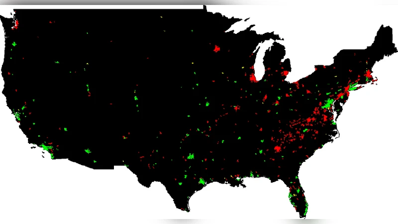
Applying this framework to more than 3,000 U.S. urban areas, the authors find strong agreement with traditional population‑density classifications. Sprawling cities are concentrated in the Sun Belt and the expanding suburbs of major metros, whereas compact cities dominate in the Northeast and in well‑planned European‑style suburbs. The methodology is then transferred to three European nations—France, Germany, and the United Kingdom—using the same OSM extraction and natural‑city definition procedures. In France, a cluster of sprawling natural cities surrounds Paris, reflecting ongoing suburbanization. Germany shows a higher proportion of compact cities, suggesting effective land‑use planning and dense transport networks. The United Kingdom exhibits a mixed pattern, with a pronounced sprawl belt around London and more compact settlements elsewhere.
The study contributes four key advances: (1) it demonstrates that OSM‑derived street nodes can serve as a reliable, high‑resolution proxy for urban population; (2) it introduces the concept of natural cities, which bypasses the limitations of arbitrary administrative borders; (3) it provides a simple, regression‑based metric for classifying sprawl that is comparable across countries; and (4) it showcases a scalable, reproducible pipeline for processing massive VGI datasets, opening the door to near‑real‑time urban growth monitoring.
Nevertheless, the authors acknowledge several limitations. OSM data quality varies geographically; regions with sparse contributor activity may yield incomplete node inventories, biasing sprawl estimates. Street nodes do not map one‑to‑one with residential units or employment sites, potentially misrepresenting functional density in industrial zones or high‑rise districts. The density threshold used to delineate natural cities is empirically chosen, and alternative thresholds could shift city boundaries and classification outcomes.
Future research directions include (a) integrating satellite‑derived built‑up masks and nighttime lights to cross‑validate node‑based population estimates; (b) extending the analysis temporally by processing historical OSM snapshots to capture dynamic sprawl trajectories; and (c) embedding the sprawl metric into scenario‑based policy models to evaluate the impact of zoning reforms, transit investments, or housing affordability interventions. By refining and expanding this approach, planners and policymakers could obtain a robust, data‑driven tool for monitoring, comparing, and ultimately mitigating unsustainable urban sprawl worldwide.
Comments & Academic Discussion
Loading comments...
Leave a Comment