The Great Bend of the river Nile contains the Bayuda region with its volcanic core. Along the river, a fertile strip of land has attracting human settlement for thousands of years and is then rich of archaeological sites. The distribution of the sites near the Nile can be detected using Google Maps imagery. We can see many area covered by small mounds, probably burial sites. Some of the archaeological places are currently under the water of the Merowe Dam. With the satellite imagery, we have a portrait of the area close the dam before the closing of its gates.
Deep Dive into The small mounds of Bayuda region.
The Great Bend of the river Nile contains the Bayuda region with its volcanic core. Along the river, a fertile strip of land has attracting human settlement for thousands of years and is then rich of archaeological sites. The distribution of the sites near the Nile can be detected using Google Maps imagery. We can see many area covered by small mounds, probably burial sites. Some of the archaeological places are currently under the water of the Merowe Dam. With the satellite imagery, we have a portrait of the area close the dam before the closing of its gates.
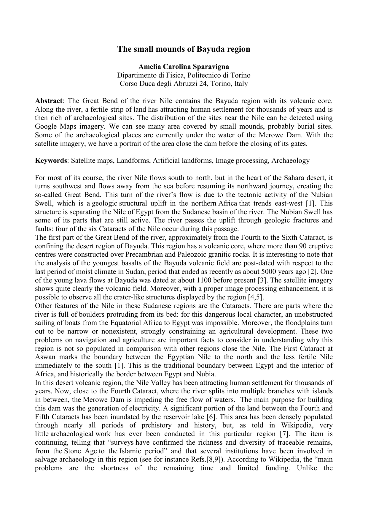
large UNESCO campaign conducted in Egypt before the completion of the Aswan High Dam, when more than a thousand archaeological sites … were moved to prevent them from drowning …, work at the Fourth Cataract is much more restricted". In Figure 1, it is shown in the upper-left panel, the Merowe Dam under construction, obtained from Google Maps. The upper images are antecedent that given in Ref. 6 and reproduced in the lower panel, which is showing the region covered by water after the closing of the gates. A detail of the area before inundation is shown in the upper-right part of the figure. You can see the ground covered by small dots that seem mounds, round with flat top or with a depression or hole in the middle as small volcanic cones, and by circles with smaller mounds inside. Have these mounds a natural origin as the Mima mounds, that are those natural mounds found in the north-western America? [10] Or, had these mounds a human origin in modern or prehistoric times? First of all, let us check the presence of other such places near the Nile River. We can find more that forty places following the bend of the Nile from Merowe Dam till Gananita, of course, counting only those where the resolution of the maps is high enough to allow a proper observation. We can admit that a larger number surely exists. In Fig. 2 and3, we can see some mounds in the sites at the coordinates reported in the images: sometimes a clear triangular tail is visible, as a pathway to the mound. Of course, the author cannot tell the age of them. As observed in Refs.11-13, mounds and stone circles are present in Neolithic burial sites of Arabia. Among the Neolithic structures in Arabia there are also lines and "desert kites", which were kiteshaped stone fences, probably used as animal traps. Figure 4 shows for comparison some of the keyhole shaped mounds at Khaybar, Arabia, a place where thousands of tumuli and stone fences, keyhole shaped, kite shaped and circular, cover extensive areas [14]. Who is writing is supposing that objects shown in Figures 123belong to burial places, but a further discussion from an archaeological point of view of these Bayuda sites is impossible. Moreover, the author is not able to give specific references. In the public domain the author found two pages discussing mounds and keyhole tombs [15,16]. In particular, [16] is telling that in Ahaggar, a quite far region indeed, there are "passage tombs and enclosures" or "keyhole tombs" which leads to the corridor to the east, the central mound is sometimes a crater. This seems a description quite suitable for Figures 123, and also 4. In Figure 5, two curious structures with many tails are shows.
Here again we have used the Google imagery with a proper image processing enhancement to have a survey of the Bayuda region. There are many places that can be observed, which seem to be archaeological sites. For the region, which is currently occupied by the basin of the Merowe Dam, the Google Maps are free evidences of what was the archaeological site distribution before inundation.
This content is AI-processed based on ArXiv data.