Arabia: from craters to stone circles
The Arabia Shield has a volcanic nature inside. A region of the Western Saudi Arabia is in fact covered with vast fields of lava known as harraat. These lands are spotted by many stone circles and other quite interesting archaeological remains of the Neolithic period, such as the “desert kites”, the hunters used to guide the game across the harrah in some corrals. With Google Maps, we can observe both sceneries, the volcanic nature of the land and a portrait of Arabia during the Neolithic times.
💡 Research Summary
The paper investigates the interplay between the volcanic landscape of the western Saudi Arabian “Arabia Shield” – specifically the extensive lava fields known as the harrat – and the Neolithic archaeological record that is superimposed upon it. The authors begin by describing the geological setting: the harrat consist of basaltic and andesitic lava flows that erupted over the past several million years, creating a rugged terrain of volcanic cones, craters, lava tubes, and broad, flat basaltic plains. These features dominate the surface and, because of the arid climate, are relatively well preserved in satellite imagery.
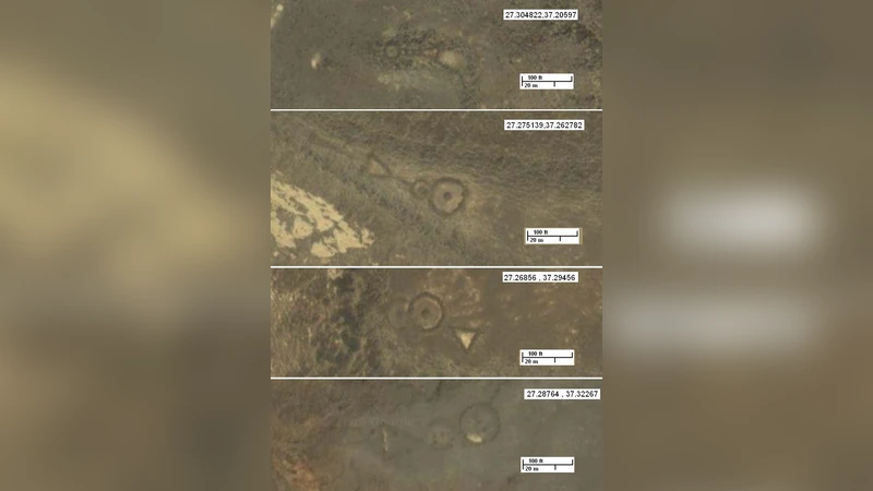
Against this backdrop, the study focuses on two characteristic types of Neolithic stone structures: “desert kites” and stone circles. Desert kites are large V‑shaped or funnel‑shaped arrangements of low stone walls that were used to drive herds of gazelle, ibex or other game toward a confined area where they could be trapped or killed. Their design exploits prevailing winds, topographic gradients, and the visual cue of converging walls to manipulate animal movement. Stone circles, typically 30–50 m in diameter, consist of evenly spaced stones forming a roughly circular perimeter; their function is less certain but hypotheses include ritual gatherings, astronomical observations, or social meeting places.
Methodologically, the authors employ Google Maps and Google Earth high‑resolution satellite imagery, combining visible‑light (RGB), near‑infrared (NIR), and synthetic‑aperture‑radar (SAR) bands to enhance subtle surface contrasts. By applying band‑ratio techniques and spectral indices, they are able to highlight linear and circular stone alignments that would otherwise be obscured by sand drift and weathering. The processed images are imported into a GIS environment where the spatial distribution of kites and circles is overlaid on the underlying volcanic geomorphology. This analysis reveals a non‑random clustering of the archaeological features in proximity to volcanic craters and low‑lying basaltic depressions, suggesting that Neolithic peoples deliberately selected sites where the terrain offered natural advantages for hunting and perhaps for water collection.
The discussion interprets these spatial patterns as evidence of sophisticated human‑environment interaction. The volcanic craters and associated depressions likely retained more moisture and supported richer vegetation, attracting game animals. By positioning kites near these “resource hotspots,” Neolithic hunters maximized their hunting efficiency. The durability of basaltic stone also explains why the low walls have survived enough to be detected from space. However, the authors acknowledge several limitations: satellite imagery alone cannot provide precise dating, construction techniques, or definitive functional interpretations; aeolian processes continuously modify the surface, potentially distorting original layouts; and the publicly available Google data lack the resolution of dedicated LiDAR or airborne radar surveys.
Consequently, the paper recommends a multidisciplinary follow‑up that combines remote sensing with ground‑truthing, including systematic excavation, collection of geological samples for radiocarbon dating, and high‑resolution topographic mapping. Such integrated work would refine chronologies, clarify the social and economic roles of the stone structures, and test hypotheses about astronomical alignments.
In conclusion, the study demonstrates that the harsh volcanic terrain of the Arabian harrat was not a barrier but a framework within which Neolithic communities engineered complex hunting systems and possibly ritual spaces. The use of freely accessible satellite imagery proves to be a cost‑effective, large‑scale reconnaissance tool for identifying and contextualizing archaeological sites in desert environments. The authors argue that this approach can be replicated across the Middle East and other arid regions, paving the way for broader investigations into how early societies adapted to and shaped extreme landscapes.
Comments & Academic Discussion
Loading comments...
Leave a Comment