Enhancing the Google imagery using a wavelet filter
In some previous papers we proposed the use of free software for a processing of the Google satellite imagery. Here we discuss the use of a wavelet filter for the same purposes. This filter is a tool included in a freely downloadable software (Iris), well-known for the processing of astronomical images. Combining the image obtained after applying the wavelet filter, with an image created with Gimp and AstroFracTool, the visibility of the landforms, as obtained from Google Maps, is strongly increased. Among several possible examples, we proposed a crater, a paleochannel and the Great Bend of the Nile.
💡 Research Summary
The paper presents a practical workflow that dramatically improves the visual clarity of Google satellite imagery by integrating three freely available image‑processing tools: GIMP, AstroFracTool, and Iris. The authors build on their earlier work that used GIMP for basic contrast and color adjustments and AstroFracTool for fractional‑gradient edge enhancement, but they note that these methods alone cannot fully exploit the multi‑scale information inherent in remote‑sensing data. To address this gap, they introduce the wavelet (wavelet‑transform) filter available in the Iris software, a program originally designed for astronomical image processing.
The methodology proceeds in five steps. First, a high‑resolution screenshot of the target area is captured from Google Maps. Second, GIMP is employed to perform standard preprocessing: histogram equalization, contrast stretching, and mild Gaussian smoothing to suppress high‑frequency noise. Third, AstroFracTool is applied to compute a fractional‑gradient map, which accentuates subtle edges and texture variations more sensitively than conventional Sobel or Canny detectors. Fourth, the pre‑processed image is imported into Iris, where a multi‑level wavelet decomposition (typically five scales: fine, medium‑fine, medium, medium‑coarse, coarse) is executed. The user can independently adjust the gain of each scale; low‑frequency (coarse) layers are kept modest to preserve overall brightness, while medium‑ and high‑frequency (fine) layers are amplified to highlight terrain micro‑features such as crater rims, channel banks, and dune ridges. Fifth, the wavelet‑enhanced layers are exported back to GIMP, blended with the original image using overlay or screen modes, and subjected to final color‑balance tweaks.
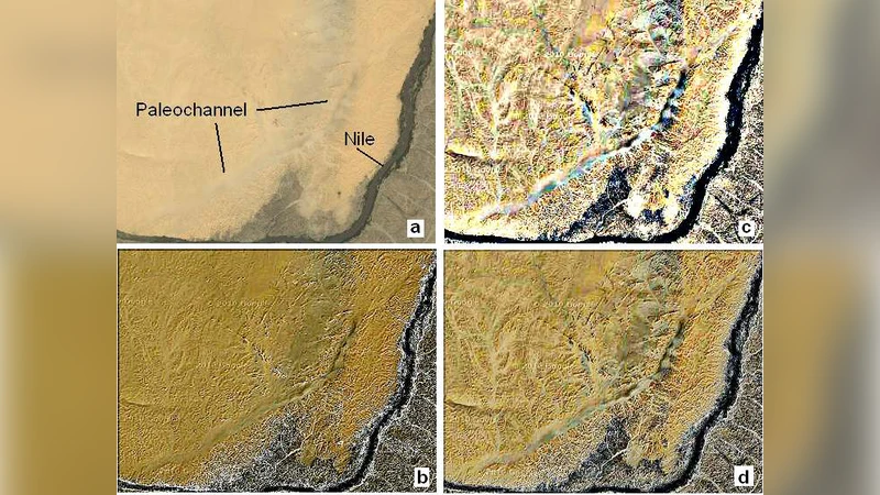
Three case studies illustrate the efficacy of the approach. (1) A small impact crater in the Sahara appears as a barely discernible depression in the raw Google image; after wavelet enhancement the crater’s circular rim becomes sharply defined, confirming the method’s ability to recover high‑frequency topographic cues. (2) An ancient paleochannel, invisible in standard satellite views, is revealed through the combined effect of AstroFracTool’s edge emphasis and the medium‑scale wavelet boost, which together expose the faint elevation differences that mark the former riverbed. (3) The Great Bend of the Nile is examined; by modestly strengthening the coarse wavelet level to retain the broad curvature of the river while accentuating the medium‑scale banks, the authors produce a visualization that simultaneously conveys large‑scale flow direction and fine‑scale fluvial morphology.
The authors discuss several advantages. Wavelet filtering operates across scales, allowing simultaneous enhancement of both global tonal balance and local texture without the artifacts typical of simple sharpening filters. The workflow relies exclusively on open‑source tools, making it accessible to researchers with limited budgets. However, they acknowledge limitations: the selection of wavelet scale gains is largely heuristic and may require expert judgment; excessive high‑frequency amplification can re‑introduce noise, especially in cloud‑covered or low‑resolution regions. They propose future work on automated parameter optimization—potentially via genetic algorithms or machine‑learning models trained on ground‑truth DEMs—and on extending the technique to other satellite platforms such as Sentinel‑2 and Landsat.
In conclusion, the study demonstrates that integrating a wavelet filter from Iris with GIMP’s basic adjustments and AstroFracTool’s fractional‑gradient enhancement yields a powerful, cost‑free pipeline for extracting subtle geomorphological features from publicly available Google imagery. This approach holds promise for a wide range of applications, including geological mapping, archaeological site detection, and environmental monitoring, where enhanced visual interpretation can guide more detailed quantitative analyses.
Comments & Academic Discussion
Loading comments...
Leave a Comment