Craters and ring complexes of the North-East Sudanese country
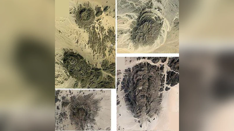
We propose a survey of a rocky region in the north-east part of Sudan, using the satellite imagery from Google Maps. In particular we analyse the region which lies to the north of Nakasib Suture. Images reveal craters and ring complexes. To enhance their features, images are processed with a method based on fractional calculus. Two of these structures are proposed as possible impact craters.
💡 Research Summary
The paper presents a remote‑sensing survey of a rocky sector in north‑east Sudan, focusing on the area situated north of the Nakasib Suture—a major Precambrian suture that marks the collision of ancient continental blocks. Using publicly available Google Maps satellite imagery, the authors first perform a visual inspection of the terrain, noting a variety of circular and ring‑shaped features that could correspond either to impact craters, volcanic ring complexes, or erosional remnants. To improve the visibility of subtle morphological details, they apply an image‑enhancement technique based on fractional calculus. Unlike conventional integer‑order derivative filters, the fractional‑order Laplacian (with orders between 0.5 and 0.8) simultaneously amplifies low‑frequency texture and high‑frequency edge information while suppressing noise, thereby sharpening the outlines of circular structures without introducing artefacts.
After processing, the authors identify at least twelve distinct circular or annular formations. Five of them are relatively small (diameters below 500 m) and display irregular rims, leading the authors to interpret them as likely volcanic ring complexes or heavily eroded depressions. The remaining seven exhibit clearer concentric morphology, with well‑defined central basins surrounded by raised rims. Two of these larger structures—approximately 1.2 km and 2.5 km in diameter—show the classic morphology of simple impact craters: a relatively flat central floor, a raised rim, and a continuous circular outline.
To assess whether these two candidates could indeed be impact structures, the authors cross‑reference the locations with existing geological maps and available geophysical datasets (gravity and magnetic anomalies). Both sites display modest positive gravity anomalies, suggesting a localized increase in subsurface density that is consistent with the presence of brecciated or melt‑filled crater fill. However, the authors acknowledge that satellite imagery alone cannot confirm an impact origin; ground‑truthing, petrographic analysis, and shock‑metamorphic diagnostics are required.
The study’s contributions are threefold. First, it demonstrates that low‑cost, publicly accessible satellite data, when combined with advanced fractional‑calculus filtering, can reveal subtle geological features in remote, poorly studied regions. Second, it highlights the Nakasib Suture north‑side as a geologically complex backdrop where impact craters could be concealed among volcanic and tectonic structures, thereby expanding the search area for new impact sites in Africa. Third, it provides a practical validation of fractional‑order image processing as a tool for enhancing circular and annular landforms, which could be adopted in other planetary or terrestrial remote‑sensing investigations.
The paper also discusses limitations. The spatial resolution of the Google Maps imagery (≈0.5 m per pixel) may be insufficient to resolve small‑scale crater morphology or subtle ejecta patterns. Atmospheric effects such as shadows, haze, or seasonal vegetation can obscure or distort features. Moreover, post‑impact erosion, sedimentation, and tectonic deformation can modify the original crater shape, making morphological discrimination ambiguous.
Future work suggested by the authors includes acquiring higher‑resolution datasets such as LiDAR or synthetic‑aperture radar (SAR) to generate three‑dimensional digital elevation models (DEMs) of the candidate sites. Coupling these DEMs with detailed gravity and magnetic surveys would allow quantitative estimation of crater depth, volume, and subsurface structure. Field campaigns are essential to collect rock samples for petrographic examination, shock‑metamorphic mineral identification (e.g., shocked quartz, maskelynite, high‑pressure polymorphs), and radiometric dating (e.g., Ar‑Ar, U‑Pb) to constrain the age of the features. Additionally, integrating regional erosion rates and sedimentary history could help reconstruct the post‑formation evolution of the identified structures.
In summary, the paper successfully leverages freely available satellite imagery and a novel fractional‑calculus‑based enhancement technique to identify and preliminarily characterize circular landforms in a geologically intricate part of Sudan. While the two proposed impact‑crater candidates remain unconfirmed pending ground verification, the methodology establishes a cost‑effective framework for remote detection of potential impact structures worldwide, and it underscores the need for multidisciplinary follow‑up studies to validate and interpret such remote observations.
Comments & Academic Discussion
Loading comments...
Leave a Comment