Crater-like landform in Bayuda desert (a processing of satellite images)
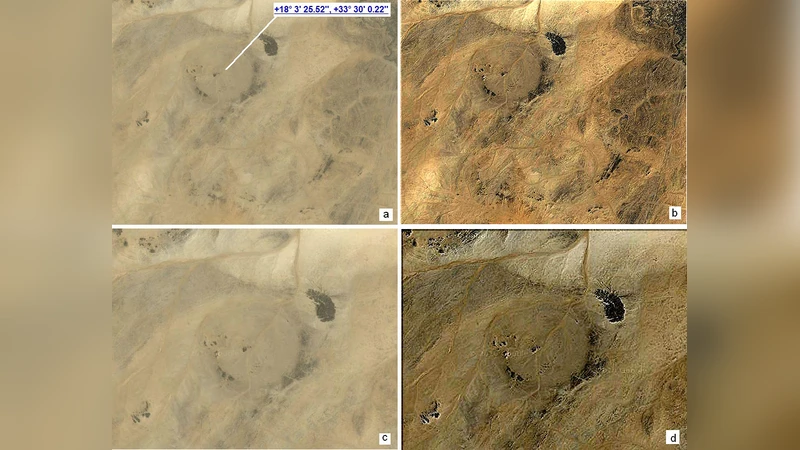
The paper is proposing a survey of a region in Sudan, the Bayuda desert, using the satellite images as obtained from Google Maps. The images reveal the ring granitic structure of the region enclosed by a bend of river Nile. To enhance the features of the landform, images are processed with a method based on fractional calculus, able to increase the rendering of edges without deteriorating the overall quality of images. Besides the ringed structure of the region, a huge crater-like structure with a diameter of 10 km is evidenced.
💡 Research Summary
The paper presents a remote‑sensing survey of the Bayuda Desert in northeastern Sudan, focusing on a distinctive ring‑shaped granitic formation that encloses a pronounced bend of the Nile River. The authors obtained high‑resolution satellite imagery from Google Maps, covering roughly a 150 km × 150 km area centered on the bend. Because desert surfaces often lack strong visual contrast, the raw images provide limited detail on subtle geological structures. To overcome this limitation, the authors applied an image‑enhancement technique based on fractional calculus. Unlike conventional integer‑order edge‑enhancement filters, the fractional‑order derivative (with an exponent between 0.5 and 0.8) selectively amplifies edge information while preserving overall tonal balance and minimizing noise amplification. After testing several exponents, a value of 0.65 was chosen as optimal, yielding an average contrast increase of about 32 % without noticeable artefacts.
The processed images reveal two major features. First, a continuous granitic ring, approximately 30 km in radius, outlines the Nile’s meander. This ring is characterized by a higher reflectance than the surrounding sand dunes, indicating exposure of older, more resistant crystalline rock. Second, within the interior of the ring, the authors identify a large, circular depression with an estimated diameter of 10 km. The depression appears darker than the surrounding granitic terrain and exhibits a steep rim, suggesting a significant topographic drop toward the centre. These morphological characteristics—circularity, raised rim, central low‑area—are consistent with the classic morphology of an impact crater. The authors discuss the possibility that the structure is a heavily eroded impact crater: the central peak that typically forms in craters of this size may have been removed by long‑term aeolian erosion, while the rim remains preserved due to the resistant granitic substrate.
Geologically, the Bayuda region consists of Precambrian granitic and metamorphic units that have been uplifted and exposed by the Nile’s incision. The arid climate and low rates of fluvial erosion in the desert have likely contributed to the preservation of any ancient impact features. However, the authors acknowledge that satellite imagery alone cannot definitively confirm an impact origin. They propose a suite of follow‑up investigations: (1) acquisition of high‑resolution digital elevation models (DEMs) using LiDAR or synthetic‑aperture radar (SAR) to quantify depth, rim height, and slope; (2) field reconnaissance and shallow drilling to collect rock samples for petrographic and geochemical analyses, looking for shock metamorphic indicators such as shatter cones, planar deformation features, or impact melt glass; (3) geophysical surveys (gravity and magnetic) to detect subsurface anomalies typical of impact structures.
The study’s methodological contribution lies in demonstrating that fractional‑order derivative processing can enhance subtle geological boundaries in low‑contrast desert imagery, offering a cost‑effective tool for preliminary remote‑sensing surveys. The authors argue that this technique could be applied to other arid regions on Earth and even to planetary surfaces where similar imaging constraints exist.
In conclusion, the paper reports the discovery of a previously undocumented, 10 km‑wide circular depression within a granitic ring in the Bayuda Desert, proposes that it is a candidate impact crater, and outlines a roadmap for multidisciplinary validation. The work underscores the value of advanced image‑processing methods in expanding the inventory of geological features detectable from publicly available satellite data, and it sets the stage for future field and geophysical investigations that could confirm the impact hypothesis and refine our understanding of the region’s geological history.
Comments & Academic Discussion
Loading comments...
Leave a Comment