SEAMONSTER: A Demonstration Sensor Web Operating in Virtual Globes
A sensor web is a collection of heterogeneous sensors which autonomously reacts to the observed environment. The SouthEast Alaska MOnitoring Network for Science, Technology, Education, and Research (SEAMONSTER) project has implemented a sensor web in partially glaciated watersheds near Juneau, Alaska, on the edge of the Juneau Icefield. By coupling the SEAMONSTER sensor web with digital earth technologies the scientific utility, education and public outreach efforts, and sensor web management of the project all greatly benefit. This paper describes the scientific motivation for a sensor web, the technology developed to implement the sensor web, the software developed to couple the sensor web with digital earth technologies, and demonstrates the SEAMONSTER sensor web in a digital earth framework.
💡 Research Summary
The paper presents SEAMONSTER, a demonstrative sensor web deployed in partially glaciated watersheds near Juneau, Alaska, and details its integration with digital‑earth platforms. The authors begin by motivating the need for high‑resolution, autonomous environmental monitoring in rapidly changing glacial environments, noting the limitations of traditional point‑based networks. They then review related work in sensor web technologies, emphasizing the novelty of coupling a heterogeneous sensor network with real‑time virtual globe visualizations.
Hardware architecture consists of low‑power wireless sensor nodes (Motes) equipped with Arduino‑compatible microcontrollers, solar panels, and battery packs. Each node measures temperature, humidity, wind speed, precipitation, stream stage, and water conductivity at five‑minute intervals. Nodes form an IEEE 802.15.4 mesh, forwarding data to a Raspberry‑Pi‑based gateway that aggregates raw CSV streams and pushes them via HTTP POST to a central server.
The software stack is built around PostgreSQL with the PostGIS extension. Incoming measurements are stored with temporal and spatial indexes, and database triggers automatically generate KML files. GeoServer exposes these layers through OGC‑WMS/WFS services, allowing Google Earth, NASA World Wind, and a custom Leaflet‑D3 dashboard to display live sensor footprints, status icons, and time‑series graphs. A RESTful API provides programmatic access for external researchers.
Autonomy is achieved on two levels. At the node level, pre‑defined thresholds (e.g., temperature above 0 °C) cause the node to increase sampling frequency or request retransmission from neighboring nodes. At the server level, a machine‑learning anomaly detector flags out‑of‑range patterns; the system then issues remote firmware updates or commands to deploy additional sensors in the affected sub‑basin. This feedback loop maintains data quality while minimizing field visits.
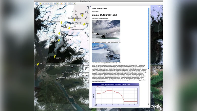
The integration with digital‑earth tools serves scientific, educational, and outreach purposes. Students can load the live KML into Google Earth, visualize glacier retreat, precipitation trends, and streamflow changes, and even edit the KML to create custom analysis layers. The public website hosts an interactive timeline, photos, and videos, broadening community engagement.
Operational challenges include power management under extreme weather, radio propagation losses in mountainous terrain, and scaling the database for long‑term, high‑frequency data. The authors address these by optimizing solar panel tilt, employing low‑power routing protocols (TinyOS + RPL), and partitioning the PostGIS database across multiple nodes. The modular design permits easy addition of new sensor types (e.g., ultrasonic flow meters) and expansion to other glacial catchments.
In conclusion, SEAMONSTER demonstrates that a well‑engineered sensor web, when tightly coupled with virtual globe technologies, can deliver near‑real‑time, high‑resolution environmental data, support advanced scientific analyses, and provide compelling educational and outreach experiences. Future work will focus on automated data analytics pipelines, cloud‑based scaling, and integration with international sensor‑web initiatives.
Comments & Academic Discussion
Loading comments...
Leave a Comment