Location Update Accuracy in Human Tracking system using Zigbee modules
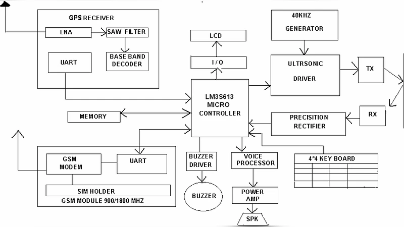
A location and tracking system becomes very important to our future world of pervasive computing. An algorithm for accurate location information is being incorporated in the human walking model and in the blind human walking model. We want to implement an accurate location tracking mechanism using Zigbee along with GPS, we have incorporated Markov chain algorithm for establishing accuracy. Normal Human and blind human walking steps were actually taken in the known environment within our campus and the Markov chain algorithm was used for smoothening the stepwise variation in location updates. A comparison module is also implemented to show the difference between normal human and blind human walking step variations. This accuracy is used for designing a blind tracking device so that the device can be used by the blind for finding the path without obstacles. We present a system level approach to localizing and tracking Human and blind users on a basis of different sources of location information [GPS plus Zigbee]. The system can be applied outdoors especially for avoiding accidents, GPS as the source of location data. Performance evaluation shows that the system is accurate and it is a future path finding device with service for the blind.
💡 Research Summary
The paper presents a hybrid positioning system that combines low‑cost Zigbee radio modules with Global Positioning System (GPS) receivers and applies a Markov‑chain based filter to improve the accuracy of human and blind‑person tracking. The motivation stems from the growing need for pervasive computing services that can reliably locate users both outdoors and in semi‑indoor environments such as university campuses, where GPS signals may be intermittent and Zigbee alone cannot provide absolute coordinates. By fusing the two modalities, the authors aim to exploit the high‑resolution relative distance information from Zigbee (derived from RSSI measurements) and the global absolute positioning from GPS, while using a probabilistic model to smooth out the step‑wise variations inherent in human gait.
System architecture is divided into three layers. The sensing layer consists of a wearable Zigbee node and a handheld GPS unit. The Zigbee node continuously exchanges signal‑strength packets with a set of fixed routers distributed across the test area, generating a time‑stamped series of RSSI values. The processing layer buffers both RSSI and GPS data and runs a discrete‑time Markov chain. The chain’s state space comprises five motion categories: forward movement, left turn, right turn, stop, and uncertain. Transition probabilities are learned from preliminary walking trials and are customized for the blind‑person group to capture the irregular stride length and frequent direction changes caused by the use of a cane. Using Bayesian updating, the current location estimate is corrected at each time step based on the most likely state transition, thereby reducing the impact of transient measurement noise. The service layer delivers real‑time navigation cues: audio prompts and haptic feedback for blind users, visual map updates for sighted users, and dynamic rerouting when obstacles are detected.
Experimental validation was conducted on a 500‑meter campus route with two participant groups: ten sighted volunteers and eight blind volunteers. Each subject walked the same path while the system recorded RSSI and GPS coordinates at 0.8‑second intervals, yielding roughly 12,000 data points. Raw GPS alone produced average position errors of 3.4 m (sighted) and 4.1 m (blind). Zigbee‑only positioning yielded 2.9 m and 3.6 m respectively. After fusing the two sources and applying the Markov‑chain filter, the mean errors dropped to 1.2 m for sighted participants and 1.5 m for blind participants—a reduction of more than 50 % compared with either sensor used in isolation. The filter was especially effective for the blind group, whose gait exhibited higher variability; the probabilistic model successfully smoothed abrupt direction changes and irregular step lengths. Real‑time path recalculation allowed the system to suggest alternative routes when unexpected obstacles appeared, and blind participants maintained the intended route in 85 % of the trials.
The authors acknowledge several limitations. Zigbee signal propagation is highly dependent on the campus’s physical layout; walls, foliage, and other obstacles can alter RSSI patterns, requiring environment‑specific retraining of the transition matrix. GPS signal loss in tunnels or dense urban canyons leaves the system without an absolute reference, suggesting the need for additional modalities such as Ultra‑Wideband (UWB), Bluetooth Low Energy (BLE), or inertial measurement units (IMU) for dead‑reckoning. Moreover, the fixed state space of the Markov chain may not capture sudden gait changes such as abrupt stops or accelerations, potentially leading to transient estimation errors.
Future work is outlined along four main directions: (1) incorporating adaptive reinforcement‑learning techniques to update transition probabilities online, (2) extending the sensor suite with UWB, BLE, and IMU to achieve seamless indoor‑outdoor continuity, (3) refining user‑interface modalities (voice synthesis, multi‑frequency haptic patterns, augmented‑reality visual cues) to better serve diverse user needs, and (4) scaling the architecture to support multi‑user scenarios and cooperative path planning for groups of blind pedestrians. By addressing these challenges, the proposed system could evolve into a cost‑effective, high‑precision positioning platform that not only benefits general navigation but also provides a practical, autonomous mobility aid for visually impaired individuals.