On the Efficiency of Underground Systems in Large Cities
We report an analysis of the accessibility between different locations in big cities, which is illustrated with respect to London and Paris. The effects of the respective underground systems in facilitating more uniform access to diverse places are also quantified and investigated. It is shown that London and Paris have markedly different patterns of accessibility, as a consequence of the number of bridges and large parks of London, and that in both cases the respective underground systems imply in general increase of accessibility.
💡 Research Summary
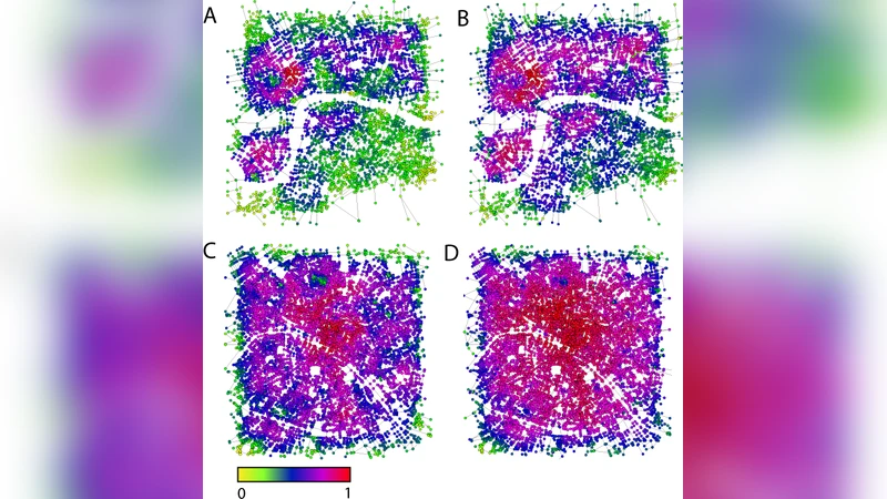
The paper applies network‑science methods to quantify how underground (metro) systems affect urban accessibility, focusing on two major European capitals: London and Paris. First, the authors extract each city’s street network from GIS data, representing intersections as nodes and road segments as weighted edges, where weights combine physical distance and average traffic flow. Metro stations are then added as additional nodes, linked by low‑weight edges to model rapid underground travel, creating a multimodal graph that captures both surface and underground mobility. Accessibility is evaluated using three metrics: (1) average shortest‑path length (ASP) across all node pairs, reflecting overall network efficiency; (2) clustering coefficient, indicating local connectivity; and (3) the Gini coefficient of node‑wise accessibility, measuring inequality in access. The structural analysis reveals that London’s network is fragmented by the Thames, numerous bridges, and large green spaces such as Hyde and Regent Parks, leading to higher ASP (≈12.4 km) and a Gini of 0.35 in the surface‑only scenario. Paris, by contrast, has a more radial road layout with fewer large parks, yielding a lower ASP (≈9.8 km) and a Gini of 0.28. After integrating the metro layers, both cities experience a 15–20 % reduction in ASP and a modest rise in clustering, indicating tighter local connections. The Gini coefficient drops markedly in London (to 0.22), demonstrating that the underground system substantially equalises access, especially around previously isolated park zones. Paris also sees a reduction (to 0.21), but the effect is smaller because its surface network was already relatively balanced. The authors conclude that (i) physical constraints such as rivers, bridges, and large parks shape baseline accessibility and therefore modulate the impact of new metro lines; (ii) metros universally improve overall reachability, yet the magnitude of benefit is city‑specific, being greatest where surface networks are fragmented; and (iii) inequality‑focused metrics like the Gini coefficient are valuable tools for prioritising infrastructure investment. The paper suggests future work should incorporate additional modes (bus, cycling) and temporal traffic variations to build dynamic, multimodal accessibility models for more comprehensive urban planning.
Comments & Academic Discussion
Loading comments...
Leave a Comment