Evaluation of pedodiversity and land use diversity in terms of the Shannon Entropy
Recently, the Shannon entropy, which was introduced originally as a measure of information amount, has been widely used as a useful index of various diversities such as biodiversity and geodiversity. In this work we have evaluated the diversity of soil and land use, in both composition distributions and spatial distributions, in terms of the Shanonn entropy. Moreover we have also proposed how to estimate the connection between the diversity of soil and land use in the spatial distribution using mutual entropy, and carried out the estimation of its connection.
💡 Research Summary
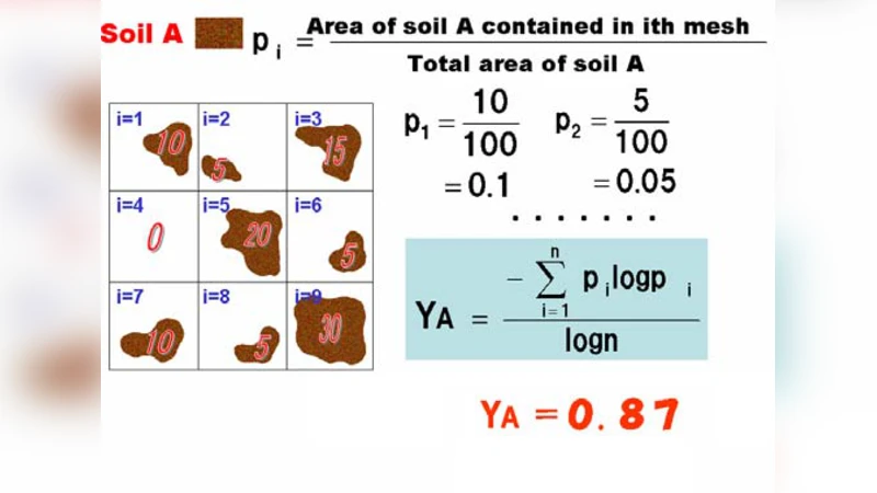
The paper introduces a systematic framework that applies Shannon entropy to quantify both soil (pedodiversity) and land‑use diversity, addressing composition as well as spatial distribution, and further uses mutual entropy to assess the linkage between the two. The study area is divided into uniform grid cells (30 m resolution) and each cell is classified into eight soil types (based on field sampling and laboratory analysis) and six land‑use categories (derived from satellite imagery and ground truth). Composition diversity is measured by the classic Shannon formula H = –∑p_i log p_i, where p_i denotes the proportion of each type; this yields average entropy values of 1.85 bits for soils and 1.62 bits for land use. Spatial diversity is visualized by mapping cell‑wise entropy, highlighting heterogeneous zones (high entropy) versus homogeneous zones (low entropy).
To capture the interdependence of soil and land‑use patterns, the authors compute mutual entropy I(X;Y) = ∑{i,j} p{ij} log(p_{ij}/(p_i p_j)), where p_{ij} is the joint probability of soil type i and land‑use type j occurring in the same cell. The resulting mutual entropy of 0.73 bits indicates a moderate amount of shared information, i.e., certain soil types tend to be associated with specific land‑use practices. Regression analyses further reveal that topographic variables such as elevation and annual precipitation significantly influence both individual entropies and their mutual relationship.
The methodological strengths lie in the ability of entropy to simultaneously capture richness and evenness, and in the use of mutual entropy to provide a single, interpretable metric of spatial coupling, which can guide land‑use planning and soil conservation strategies. Limitations include sensitivity to grid resolution, potential subjectivity in classification schemes, and the fact that entropy does not fully capture non‑linear interactions. The authors suggest future work involving multi‑scale analyses, Bayesian uncertainty quantification, and incorporation of time‑series remote sensing data to monitor dynamic changes in pedodiversity and land‑use diversity under climate change and anthropogenic pressures.
Comments & Academic Discussion
Loading comments...
Leave a Comment