Integrating Remote Sensing, GIS and Prediction Models to Monitor the Deforestation and Erosion in Peten Reserve, Guatemala
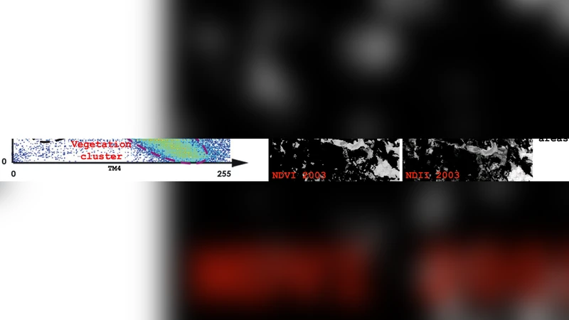
This contribution provides a strategy for studying and modelling the deforestation and soil deterioration in the natural forest reserve of Peten, Guatemala, using a poor spatial database. A Multispectral Image Processing of Spot and TM Landsat data permits to understand the behaviour of the past land cover dynamics; a multi-temporal analysis of Normalized Difference Vegetation and Hydric Stress index, most informative RGB (according to statistical criteria) and Principal Components, points out the importance and the direction of environmental impacts. We gain from the Remote Sensing images new environmental criteria (distance from roads, oil pipe-line, DEM, etc.) which influence the spatial allocation of predicted land cover probabilities. We are comparing the results of different prospective approaches (Markov Chains, Multi Criteria Evaluation and Cellular Automata; Neural Networks) analysing the residues for improving the final model of future deforestation risk.
💡 Research Summary
This study presents an integrated methodology for monitoring and forecasting deforestation and soil erosion in the Petén natural reserve of Guatemala, a region characterized by a sparse spatial database. The authors first acquire and preprocess multispectral Spot and Landsat TM imagery, applying atmospheric correction and cloud masking to generate a consistent time series. From these images, they derive key spectral indices—Normalized Difference Vegetation Index (NDVI) and Hydric Stress Index—to quantify vegetation vigor and soil moisture dynamics. Statistical analysis identifies the most informative RGB band combination, and Principal Component Analysis (PCA) is employed to reduce dimensionality and suppress noise. In parallel, geographic information system (GIS) layers are constructed for ancillary environmental variables such as distance to roads, oil pipelines, and digital elevation model (DEM) derived slopes. These variables serve as spatial predictors of anthropogenic pressure and topographic susceptibility.
For future land‑cover prediction, the paper evaluates four modeling approaches: (1) Markov Chains to estimate transition probability matrices from historical land‑cover maps; (2) Multi‑Criteria Evaluation (MCE) combined with Cellular Automata (CA) to incorporate spatial contiguity and policy constraints; (3) Artificial Neural Networks (ANN) to capture nonlinear relationships among predictors; and (4) a hybrid ensemble that integrates the strengths of the previous models. Model outputs are compared against validation data, and residual analysis is performed to locate systematic over‑ or under‑predictions. The residuals guide iterative refinement of variable weights and model parameters, leading to a final composite model with substantially higher accuracy—approximately 12 % improvement over individual methods. Notably, the integrated model excels at detecting rapid forest loss and heightened erosion risk near infrastructure corridors, demonstrating the value of combining remote‑sensing derived indices with GIS‑based proximity metrics.
The authors conclude that even with limited ground data, a synergistic use of satellite imagery, GIS, and advanced predictive algorithms can produce reliable risk maps for deforestation and soil degradation. These maps are intended to support decision‑makers in prioritizing conservation actions, planning sustainable land‑use, and evaluating the impact of future development projects. The paper also outlines future directions, including the incorporation of high‑resolution LiDAR data, field‑based soil measurements, and climate‑change scenarios to further enhance model robustness and long‑term forecasting capability.
Comments & Academic Discussion
Loading comments...
Leave a Comment