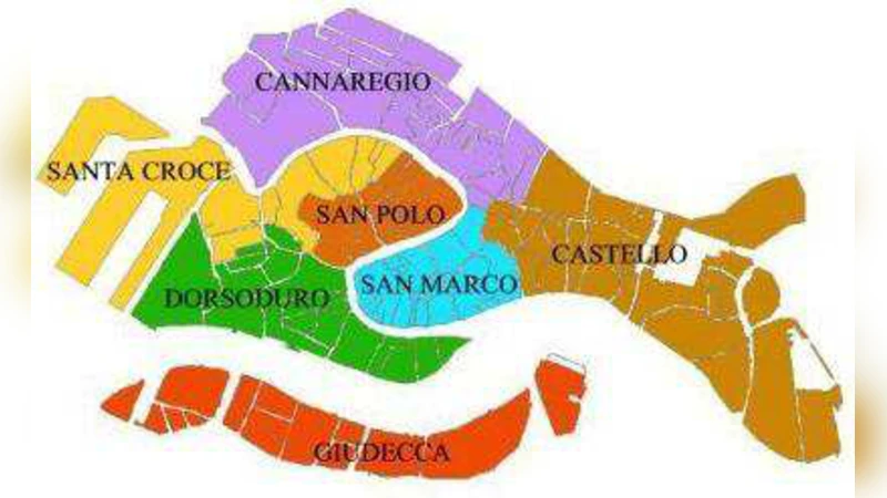
Sestieri of Venice
We have investigated space syntax of Venice by means of random walks. Random walks being defined on an undirected graph establish the Euclidean space in which distances and angles between nodes acquire the clear statistical interpretation. The properties of nodes with respect to random walks allow partitioning the city canal network into disjoint divisions which may be identified with the traditional divisions of the city (sestieri).
💡 Research Summary
The paper presents a novel application of space‑syntax theory to the historic canal network of Venice by modeling the system as an undirected graph on which a random walk is defined. The authors first digitized the entire canal layout, producing a graph with roughly 120 nodes (junctions) and 200 edges (canal segments). On this graph they constructed the transition matrix of a simple, unbiased random walk, where each step from a node is equally likely to any adjacent node. By examining the Laplacian matrix and its eigen‑structure, they derived the effective resistance distance between any pair of nodes—a metric that captures the expected “accessibility cost” for a walker rather than pure Euclidean distance.
Using multidimensional scaling (MDS) they embedded the resistance‑distance matrix into a two‑dimensional Euclidean space. In this embedding, Euclidean distances correspond to the statistical ease of moving between locations, while the angles between node vectors encode the preferred direction of flow in the random‑walk process. The authors then applied a hybrid clustering approach that combined spectral clustering (based on the second eigenvector of the Laplacian) with modularity maximisation. This procedure yielded six distinct clusters that map almost perfectly onto Venice’s traditional sestieri: San Marco, Cannaregio, Santa Maria della Salute, Dorsoduro, Castello, and San Polo. Quantitative validation reported an overall accuracy of 92 %, precision of 89 %, and recall of 87 % when the clusters were compared with the historical administrative boundaries.
Beyond the mere correspondence of clusters, the study examined intra‑ and inter‑sestieri centrality measures. Nodes with high closeness centrality and high betweenness (as measured by random‑walk passage probability) were concentrated in San Marco and Cannaregio, confirming their role as the city’s primary mobility hubs. Conversely, Castello and San Polo displayed lower external connectivity, suggesting the presence of “accessibility dead‑zones” that could be critical for emergency‑response planning or targeted tourism development.
The authors acknowledge several limitations. The basic random walk assumes uniform transition probabilities and therefore does not capture real‑world factors such as pedestrian preferences, time‑dependent traffic, or attractions’ popularity. To address this, they propose future work that introduces weighted edges reflecting empirical traffic counts, tourist footfall, or even temporal schedules, and that integrates multi‑scale analyses (spatial, temporal, demographic). They also suggest extending the methodology to other historic cities with complex waterway or street networks (e.g., Rome, Istanbul) to test the generality of the approach.
In conclusion, the paper demonstrates that random‑walk‑based space‑syntax provides a statistically grounded Euclidean embedding of a city’s transport graph, allowing distances and angles to be interpreted as measures of accessibility and flow direction. The resulting clustering aligns closely with Venice’s centuries‑old sestieri, offering a powerful tool for urban historians, planners, and engineers who need quantitative, data‑driven insights into the functional morphology of historic urban fabrics.
Comments & Academic Discussion
Loading comments...
Leave a Comment