Support Vector Machines (SVMs) are a relatively new supervised classification technique to the land cover mapping community. They have their roots in Statistical Learning Theory and have gained prominence because they are robust, accurate and are effective even when using a small training sample. By their nature SVMs are essentially binary classifiers, however, they can be adopted to handle the multiple classification tasks common in remote sensing studies. The two approaches commonly used are the One-Against-One (1A1) and One-Against-All (1AA) techniques. In this paper, these approaches are evaluated in as far as their impact and implication for land cover mapping. The main finding from this research is that whereas the 1AA technique is more predisposed to yielding unclassified and mixed pixels, the resulting classification accuracy is not significantly different from 1A1 approach. It is the authors conclusions that ultimately the choice of technique adopted boils down to personal preference and the uniqueness of the dataset at hand.
Deep Dive into Classification of Images Using Support Vector Machines.
Support Vector Machines (SVMs) are a relatively new supervised classification technique to the land cover mapping community. They have their roots in Statistical Learning Theory and have gained prominence because they are robust, accurate and are effective even when using a small training sample. By their nature SVMs are essentially binary classifiers, however, they can be adopted to handle the multiple classification tasks common in remote sensing studies. The two approaches commonly used are the One-Against-One (1A1) and One-Against-All (1AA) techniques. In this paper, these approaches are evaluated in as far as their impact and implication for land cover mapping. The main finding from this research is that whereas the 1AA technique is more predisposed to yielding unclassified and mixed pixels, the resulting classification accuracy is not significantly different from 1A1 approach. It is the authors conclusions that ultimately the choice of technique adopted boils down to personal pre
Over the last three decades or so, remote sensing has increasingly become a prime source of land cover information (Kramer, 2002;Foody and Mathur, 2004a). This has been made possible by advancements in satellite sensor technology thus enabling the acquisition of land cover information over large areas at various spatial, temporal spectral and radiometric resolutions. The process of relating pixels in a satellite image to known land cover is called image classification and the algorithms used to effect the classification process are called image classifiers (Mather, 1987). The extraction of land cover information from satellite images using image classifiers has been the subject of intense interest and research in the remote sensing community (Foody and Mather, 2004b). Some of the traditional classifiers that have been in use in remote sensing studies include the maximum likelihood, minimum distance to means and the box classifier. As technology has advanced, new classification algorithms have become part of the main stream image classifiers such as decision trees and artificial neural networks. Studies have been made to compare these new techniques with the traditional ones and they have been observed to post improved classification accuracies (Peddle et al. 1994;Rogan et al. 2002;Li et al. 2003;Mahesh and Mather, 2003). In spite of this, there is still considerable scope for research for further increases in accuracy to be obtained and a strong desire to maximize the degree of land cover information extraction from remotely sensed data (Foody and Mather, 2004b). Thus, research into new methods of classification has continued, and support vector machines (SVMs) have recently attracted the attention of the remote sensing community (Huang et al., 2002). Support Vector Machines (SVMs) have their roots in Statistical Learning Theory (Vapnik, 1995). They have been widely applied to machine vision fields such as character, handwriting digit and text recognition (Vapnik, 1995;Joachims, 1998), and more recently to satellite image classification (Huang et al, 2002;Mahesh and Mather, 2003). SVMs, like Artificial Neural Networks and other nonparametric classifiers have a reputation for being robust (Foody and Mathur, 2004a;Foody and Mathur, 2004b). SVMs function by nonlinearly projecting the training data in the input space to a feature space of higher (infinite) dimension by use of a kernel function. This results in a linearly separable dataset that can be separated by a linear classifier. This process enables the classification of remote sensing datasets which are usually nonlinearly separable in the input space. In many instances, classification in high dimension feature spaces results in over-fitting in the input space, however, in SVMs over-fitting is controlled through the principle of structural risk minimization (Vapnik, 1995). The empirical risk of misclassification is minimised by maximizing the margin between the data points and the decision boundary (Mashao, 2004). In practice this criterion is softened to the minimisation of a cost factor involving both the complexity of the classifier and the degree to which marginal points are misclassified. The tradeoff between these factors is managed through a margin of error parameter (usually designated C) which is tuned through cross-validation procedures (Mashao, 2004). The functions used to project the data from input space to feature space are sometimes called kernels (or kernel machines), examples of which include polynomial, Gaussian (more commonly referred to as radial basis functions) and quadratic functions. Each function has unique parameters which have to be determined prior to classification and they are also usually determined through a cross validation process. A deeper mathematical treatise of SVMs can be found in Christianini (2002), Campbell (2000) and Vapnik (1995).
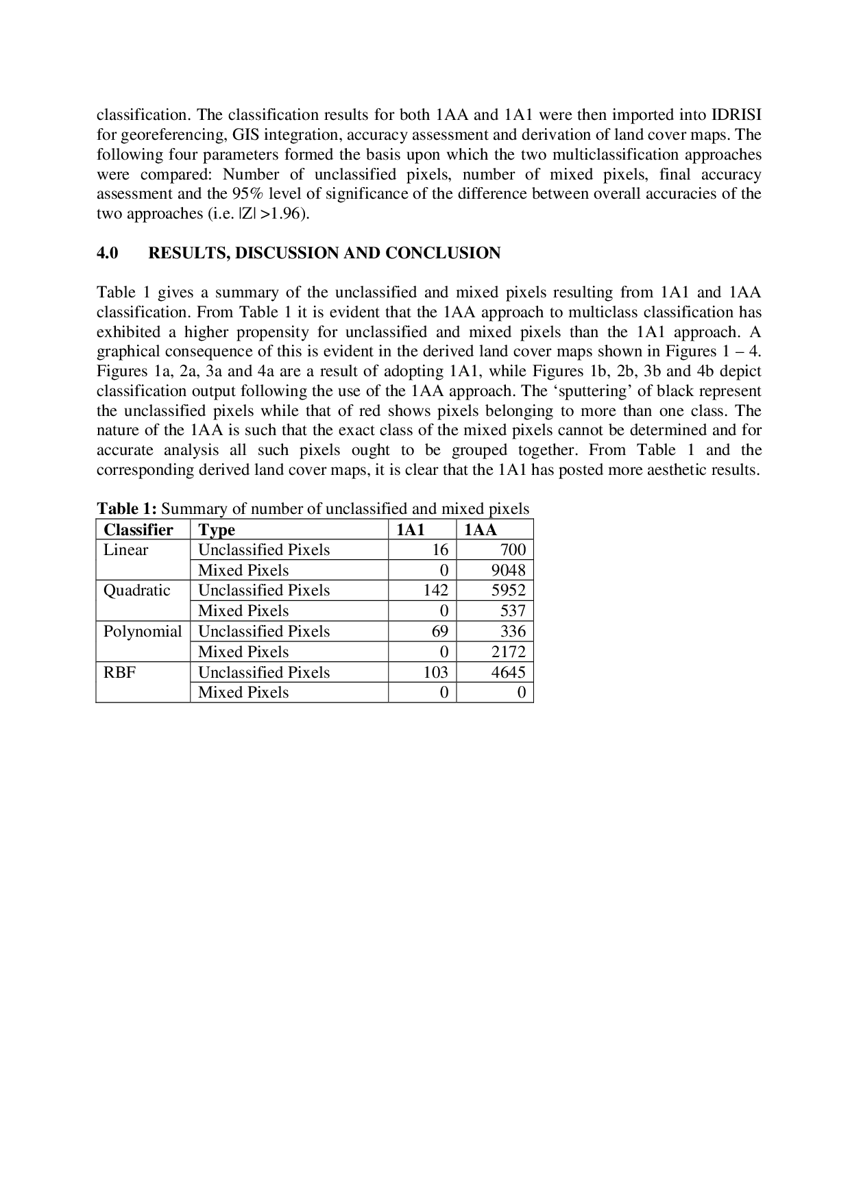
By their nature SVMs are intrinsically binary classifiers (Melgani and Bruzzone, 2004) however there exist strategies by which they can be adopted to multiclass tasks associated with remote sensing studies. Two of the common approaches are the One-Against-One (1A1) and One-Against-All (1AA) techniques. This paper seeks to explore these two approaches with a view of discussing their implications for the classification of remotely sensed images.
As mentioned before, SVM classification is essentially a binary (two-class) classification technique, which has to be modified to handle the multiclass tasks in real world situations e.g. derivation of land cover information from satellite images. Two of the common methods to enable this adaptation include the 1A1 and 1AA techniques. The 1AA approach represents the earliest and most common SVM multiclass approach (Melgani and Bruzzone, 2004) and involves the division of an N class dataset into N two-class cases. If say the classes of interest in a satellite image include water, vegetation and built up areas, classification would be effected by
…(Full text truncated)…
This content is AI-processed based on ArXiv data.