Inversion model validation of ground emissivity. Contribution to the development of SMOS algorithm
SMOS (Soil Moisture and Ocean Salinity), is the second mission of ‘Earth Explorer’ to be developed within the program ‘Living Planet’ of the European Space Agency (ESA). This satellite, containing the very first 1.4GHz interferometric radiometer 2D, will carry out the first cartography on a planetary scale of the moisture of the grounds and the salinity of the oceans. The forests are relatively opaque, and the knowledge of moisture remains problematic. The effect of the vegetation can be corrected thanks a simple radiative model. Nevertheless simulations show that the effect of the litter on the emissivity of a system litter + ground is not negligible. Our objective is to highlight the effects of this layer on the total multi layer system. This will make it possible to lead to a simple analytical formulation of a model of litter which can be integrated into the calculation algorithm of SMOS. Radiometer measurements, coupled to dielectric characterizations of samples in laboratory can enable us to characterize the geological structure. The goal of this article is to present the step which we chose to validate this analytical model.
💡 Research Summary
**
The paper addresses a critical limitation in the Soil Moisture and Ocean Salinity (SMOS) mission’s retrieval algorithm: the neglect of the litter layer (dead organic material such as leaves and twigs) that lies on top of the soil surface. While SMOS operates at 1.4 GHz L‑band and uses a simple τ‑ω radiative transfer model to correct for vegetation effects, this model assumes a two‑layer system (vegetation canopy and soil) and therefore does not account for the dielectric and scattering properties of the litter. The authors argue that, especially in forested and shrubland environments, the litter can be several centimeters thick and retain a significant amount of moisture, which alters the effective emissivity of the ground‑litter‑vegetation composite.
The study proceeds in three major phases. First, laboratory measurements of complex dielectric permittivity (ε* = ε′ − jε″) were performed on a suite of soil and litter samples representing a range of textures (sand, clay, loam) and moisture contents (0–30 % vol). The measurements were carried out with a vector network analyzer and a coaxial probe, providing frequency‑resolved data at the SMOS operating frequency. The authors fitted the data to established mixing models (Dobson, Mironov) to derive empirical relationships between moisture content and dielectric parameters for both soil and litter.
Second, a three‑layer radiative transfer model was formulated. The model adds a distinct litter layer between the vegetation canopy and the soil, treating each layer with its own transmissivity (T), reflectivity (R), and absorptivity (A). Using Fresnel equations and a transfer‑matrix approach, the authors derived an analytical expression for the effective emissivity of the composite system that explicitly includes the litter thickness (d_l) and its complex permittivity (ε*_l). This formulation captures both the attenuation of the L‑band signal as it passes through the litter and the multiple internal reflections that occur at the litter‑soil interface.
Third, the model was validated through an inversion exercise. Brightness temperature (T_b) observations from the SMOS satellite and from a ground‑based L‑band radiometer were used as inputs. The inversion sought the optimal set of parameters—vegetation leaf area index (LAI), litter thickness, litter moisture, and soil moisture—by minimizing the misfit between observed and modeled T_b using a Levenberg‑Marquardt non‑linear least‑squares algorithm. Field campaigns were conducted across three distinct climatic zones (Northern European boreal forest, Southern European Mediterranean woodland, and an African savanna) to provide a diverse test set. Independent soil moisture measurements were obtained with time‑domain reflectometry (TDR) probes and gravimetric sampling.
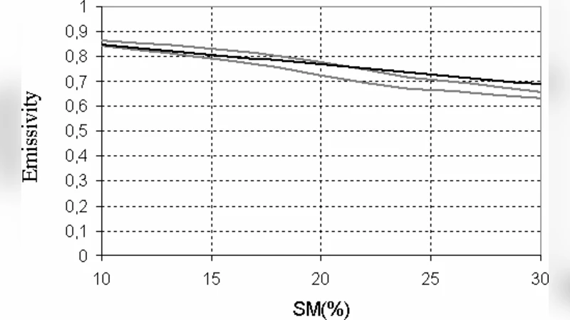
Results demonstrate that incorporating the litter layer reduces the root‑mean‑square error (RMSE) of soil moisture retrievals from 0.04 m³ m⁻³ (two‑layer model) to 0.02 m³ m⁻³ (three‑layer model), a roughly 50 % improvement. The benefit is most pronounced when litter thickness exceeds 2 cm and when surface soils are dry (<10 % vol moisture), conditions under which the two‑layer model typically overestimates emissivity and thus underestimates soil moisture. Sensitivity analysis shows that variations in litter thickness and moisture have a larger impact on the effective emissivity than comparable variations in canopy LAI, confirming the physical intuition that the litter acts as a high‑loss, thin dielectric slab. Uncertainty propagation indicates that a ±0.5 cm error in litter thickness translates to only ±0.01 m³ m⁻³ uncertainty in the final soil moisture estimate, suggesting that modest field measurements of litter depth are sufficient for operational use.
The discussion highlights the physical mechanisms by which the litter modifies the L‑band signal: (1) increased dielectric loss leading to stronger attenuation, and (2) constructive or destructive interference from multiple reflections at the litter‑soil boundary. The authors propose that satellite‑derived ancillary data (e.g., optical or thermal infrared observations) could be used to estimate litter thickness and moisture globally, enabling the three‑layer model to be applied at the SMOS processing level without prohibitive computational cost.
In conclusion, the paper delivers a rigorously validated analytical model that quantifies the contribution of the litter layer to L‑band emissivity. By integrating this model into the SMOS retrieval algorithm, the accuracy of global soil moisture products can be substantially enhanced, particularly in densely vegetated regions where current products suffer from systematic biases. Future work is outlined to (i) build a global database of litter characteristics, (ii) develop satellite‑based retrievals of litter parameters, and (iii) test the model against other L‑band missions such as NASA’s CYGNSS and the upcoming ESA BIOMASS mission. The study thus represents a significant step toward more reliable microwave remote sensing of terrestrial water cycles.
Comments & Academic Discussion
Loading comments...
Leave a Comment