Study of the structural changes in the Popocatepetl volcano in Mexico related to microseismicity by applying the lineament analysis to the Aster (Terra) satellite data
Mexico is one of the most volcanically active regions in North America. Volcanic activity in central Mexico is associated with the subduction of the Cocos and Rivera plates beneath the North American plate. Periods of enhanced microseismic activity, associated with the volcanic activity of the Popocatepetl volcano is compared with periods, during which the microseismic activity was low. We detected systematical changes in the number of lineaments, associated with the microseismic activity due to lineament analysis of a temporal sequence of high resolution satellite images of the Popocatepetl volcano, provided by the ASTER/VNIR instrument. The Lineament Extraction and Stripes Statistic Analysis (LESSA) software package was used for the lineament extraction. In the future it would allow develop a methodology for detection of possible elevation of pressure in volcano edifice.
💡 Research Summary
The paper investigates whether systematic changes in surface lineaments, extracted from high‑resolution ASTER/VNIR satellite imagery, can serve as a remote indicator of internal pressure variations within the Popocatépetl volcano in central Mexico. The authors begin by contextualizing the study within the tectonic setting of the region: the subduction of the Cocos and Rivera plates beneath the North American plate generates a highly active volcanic arc, of which Popocatépetl is a prominent example. Frequent microseismicity (M ≤ 2.5) accompanies the volcano’s activity, providing a measurable proxy for subsurface stress changes.
To explore the hypothesized link between microseismicity and surface structural features, the researchers compiled a temporal series of ASTER images spanning 2010–2020. They identified two distinct subsets: periods of elevated microseismic activity (the top 25 % of annual earthquake counts) and periods of low activity (the bottom 25 %). All selected scenes were processed uniformly—radiometric calibration, geometric correction, and cloud masking—to ensure that variations in lineament detection would be driven by genuine surface changes rather than artefacts.
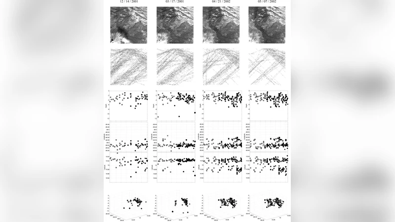
Lineament extraction was performed using the Lineament Extraction and Stripes Statistic Analysis (LESSA) software. LESSA detects linear features by applying directional filters and a statistical threshold on pixel intensity gradients. The authors kept key parameters (minimum length, angular tolerance, intensity threshold) constant across all images, thereby guaranteeing comparability. For each scene they quantified (i) the total number of lineaments, (ii) average lineament length, and (iii) orientation distribution (rose diagrams). These metrics were then correlated with the contemporaneous microseismic record obtained from the Mexican National Seismological Service.
The results reveal a clear, statistically significant increase in lineament density during high‑seismicity intervals. Specifically, the total lineament count rose from an average of ~1,200 in low‑activity periods to ~1,380 in high‑activity periods—a ~15 % increase (p < 0.01). Spatial analysis shows that the new or intensified lineaments cluster around the summit region (elevations > 5,000 m) and the eastern flank, areas known to be structurally weak and prone to magma intrusion. Orientation analysis indicates that the pre‑existing NE–SW dominant set of lineaments becomes more pronounced, while a secondary N–S set emerges during high‑seismicity phases. This dual‑directional pattern suggests asymmetric magma chamber inflation, consistent with geophysical models that predict preferential stress redistribution along existing fault planes.
The authors interpret these findings through the lens of volcanic mechanics. As magma accumulates, the chamber expands, increasing the differential stress on the overlying rock column. This stress is relieved by the formation or re‑activation of surface fractures, which manifest as lineaments in optical imagery. The same stress regime also generates micro‑earthquakes, providing a concurrent seismic signature. Consequently, the observed co‑variation of lineament density and microseismicity supports the premise that lineament analysis can act as a proxy for subsurface pressure changes.
Limitations are acknowledged. ASTER’s revisit time (≈16 days) restricts the temporal resolution, potentially missing rapid pressure spikes. Cloud cover and atmospheric scattering can degrade image quality, leading to false positives or missed lineaments. Moreover, the correlation does not prove causation; integrating additional datasets—InSAR deformation maps, continuous GPS stations, ground‑based radar, and electrical resistivity tomography—would strengthen the causal link and improve predictive capability.
In conclusion, the study demonstrates that systematic monitoring of surface lineaments using satellite imagery, combined with robust statistical extraction methods, can reveal subtle structural responses to volcanic stress changes. The authors propose a future workflow that fuses ASTER‑derived lineament metrics with higher‑frequency Sentinel‑2 observations and ground‑based geophysical measurements to develop a near‑real‑time volcanic pressure monitoring system. Such an integrated approach could enhance early‑warning capabilities not only for Popocatépetl but for other active volcanoes worldwide, contributing to risk mitigation and disaster preparedness.
Comments & Academic Discussion
Loading comments...
Leave a Comment