Limits of the seismogenic zone in the epicentral region of the 26 December 2004 great Sumatra-Andaman earthquake: Results from seismic refraction and wide-angle reflection surveys and thermal modeling
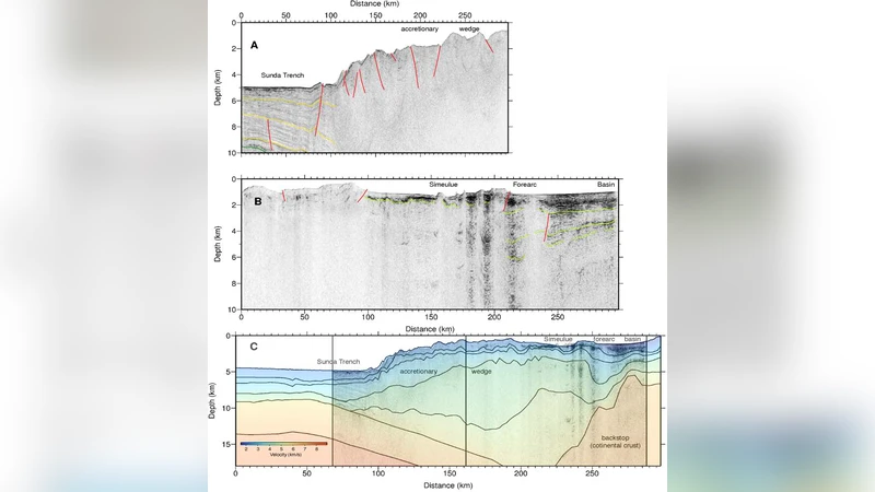
The 26 December 2004 Sumatra earthquake (Mw = 9.1) initiated around 30 km depth and ruptured 1300 km of the Indo-Australian Sunda plate boundary. During the Sumatra OBS (ocean bottom seismometer) survey, a wide angle seismic profile was acquired across the epicentral region. A seismic velocity model was obtained from combined travel time tomography and forward modeling. Together with reflection seismic data from the SeaCause II cruise, the deep structure of the source region of the great earthquake is revealed. Four to five kilometers of sediments overlie the oceanic crust at the trench, and the subducting slab can be imaged down to a depth of 35 km. We find a crystalline backstop 120 km from the trench axis, below the fore arc basin. A high velocity zone at the lower landward limit of the raycovered domain, at 22 km depth, marks a shallow continental Moho, 170 km from the trench. The deep structure obtained from the seismic data was used to construct a thermal model of the fore arc in order to predict the limits of the seismogenic zone along the plate boundary fault. Assuming 100C-150C as its updip limit, the seismogenic zone is predicted to begin 530 km from the trench. The downdip limit of the 2004 rupture as inferred from aftershocks is within the 350C 450C temperature range, but this limit is 210-250 km from the trench axis and is much deeper than the fore arc Moho. The deeper part of the rupture occurred along the contact between the mantle wedge and the downgoing plate.
💡 Research Summary
The paper presents a comprehensive geophysical investigation of the source region of the Mw 9.1 Sumatra‑Andaman earthquake of 26 December 2004. The authors combined ocean‑bottom seismometer (OBS) wide‑angle seismic profiling, multichannel reflection data from the SeaCause II cruise, and thermal modeling to delineate the geometry of the subduction interface and to predict the up‑dip and down‑dip limits of the seismogenic zone.
First, travel‑time tomography and forward modeling of the OBS data yielded a high‑resolution 2‑D velocity model. The model shows a 4–5 km thick sedimentary cover overlying a thin oceanic crust at the trench, with the downgoing Indo‑Australian slab imaged down to ~35 km depth. A crystalline back‑stop is identified 120 km landward of the trench, beneath the fore‑arc basin. At the landward edge of the ray‑covered domain, a high‑velocity zone at 22 km depth marks a shallow continental Moho located ~170 km from the trench.
Second, the reflection seismic lines corroborate the velocity model, clearly delineating the fore‑arc sedimentary sequences, the oceanic‑crust–mantle interface, and the continental Moho. The integration of both data sets confirms that the seismogenic interface initiates beneath a relatively thin sedimentary pile and that the continental Moho is unusually shallow in this segment of the Sunda margin.
Third, the structural framework was used as input for a steady‑state thermal model of the fore‑arc. The model incorporates radiogenic heat production, conductive cooling, and the advective heat flux associated with slab subduction (assumed convergence rate ~2 cm yr⁻¹). The authors adopt 100 °C–150 °C as the thermal up‑dip limit of stable stick‑slip behavior and 350 °C–450 °C as the down‑dip limit where ductile flow dominates. The calculated isotherms indicate that the 100 °C–150 °C contour lies ~530 km landward of the trench, far beyond the location of the shallow Moho. Conversely, the 350 °C–450 °C contour intersects the slab at 210–250 km from the trench, a distance that matches the observed aftershock distribution and the inferred down‑dip termination of the 2004 rupture.
Finally, the authors compare the thermal predictions with the actual rupture geometry inferred from aftershocks, GPS, and tsunami modeling. The down‑dip limit of the 2004 event falls within the 350 °C–450 °C temperature range, but it is considerably deeper than the shallow continental Moho, indicating that the rupture propagated along the interface between the mantle wedge and the downgoing plate rather than being confined to the crustal portion of the slab. This observation challenges the conventional view that megathrust earthquakes are limited to the crustal segment of the subduction interface and suggests that, at least in this region, the seismogenic zone can extend into the mantle wedge‑slab contact.
Key conclusions are: (1) the fore‑arc structure comprises a thin sedimentary pile, a shallow oceanic crust, a well‑imaged downgoing slab to ~35 km depth, a crystalline back‑stop at 120 km landward, and a shallow continental Moho at ~170 km from the trench; (2) thermal modeling predicts an up‑dip limit of the seismogenic zone at ~530 km from the trench and a down‑dip limit at 210–250 km, consistent with aftershock locations; (3) the 2004 rupture’s deepest portion occurred below the Moho, along the mantle wedge‑slab interface, implying that megathrust rupture can involve mantle material. The integrated seismic‑thermal approach demonstrated here provides a robust framework for assessing seismogenic potential along other subduction zones worldwide.
Comments & Academic Discussion
Loading comments...
Leave a Comment